Since morning Mom and dad had been neatly hiding the clues all around the backyard and the house. Today was Easter and five of my closest friends were going to join me for Easter egg treasure hunt in the evening. I was to told to stay in my room until my parents were done. I did not mind it. I wanted the thrill of seeking the treasure with my friends.
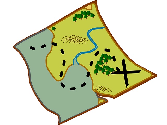
Mom and Dad walked into my room just before noon. They told me that since my friends weren’t so familiar with the territory, they have made a map for the treasure hunt. This would help for all of us in efficiently finding hidden Easter eggs. The plan was perfect except for one thing. We were just a bunch of six year olds and did not know how to read maps.
Dad decided to ease my worry by telling me a little something about maps. I got excited to learn a new thing and then show it off to my friends. As usual, dad started from the very beginning. What are maps? Of course, I knew that much. I told him that the map is a drawing of an area of land or sea showing features like rivers, mountains, cities, roads, etc. Dad added that maps can be of vast areas like countries or can be of a much smaller areas like a neighborhood or even a house. The main purpose of the map is to tell us what lies where. Basically, a map gives us a sense of location and direction.
Map can be used to depict anything – a street, a country, a forest, even our solar system! In earlier times, maps were always used by sailors and travelers to keep a track of the directions. These maps were drawn on leaves, cloth or even egg shells! These days we have electronic maps. A person who makes maps is called a cartographer and art of map making is called cartography.
Dad then told me that the most common orientation of a map is that North is at the top of a map. This means that if you are moving in an upward direction on the map, you are moving in North direction in real. Many, but not all, maps are drawn to a scale. This means that the distance shown between two places on the map, isn’t the actual distance but still gives a fair idea of the distance between two places. Distances on maps are usually expressed as a ratio. For example, 1 cm on a map might be equivalent to 100 km in real. Then he said that in informal maps, like the one we have made for the treasure hunt, has not been drawn to scale. Dad also told that various features like mountains, rivers, volcanoes are represented on the map by conventional signs or symbols.
In the evening, one by one all my friends arrived. We were handed the map of my house and yard. I unrolled the map and told my friends about how should we read the map. It wasn’t tricky at all ! There was a start sign on the map. We had to start from where the rose bushes in the yard were. We rushed and eagerly gathered there. There were numbers written around the hiding sites, and the arrows were drawn for directions to follow. We all gazed at the map for a minute, looked up and then ran. We exactly knew what we had to do. The first arrow lead us behind the shed. There was number “1” written there. We rolled and kept the map aside and started looking for the eggs. After about 20 minutes of craziness, we found the five eggs hidden in the holder where paint brushes were kept. We proudly collected them in our basket.
It was turning out to be a super fun evening. All my friends loved the idea of following the map for the treasure hunt. It was time to follow another arrow in order to find the next prize.


Leave a Reply